The Streets of Flooded San Francisco
After the damage and flooding wreaked by Hurricane Sandy, one has to wonder whether San Francisco could be hit by such a storm. Will rising seas mixed with an El Niño induced Pineapple Express be enough to flood downtown San Francisco or erase Ocean Beach?
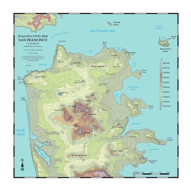
Several months ago we made a similar map showing 25 foot sea level rise showcasing topography. Several people commented that they liked the map but wanted to find out whether or not they would be above or below water. Now you can actually find whether you'll be affected with this new street map version.
 We don't know which neighborhoods will be worst hit after a given storm, but we do know sea levels are rising, and that with climate change, those hurricanes off Mexico's Pacific Coast could come north some day. We don't know when or how severe, but we could get a 25 foot storm surge at some point.
Below is a map of San Francisco showing what our coast would look like with a 25 foot storm surge or basic 25 foot sea level rise.

You can buy this map as a poster at Zazzle.
24"x 24" ($20)
You can also learn more about the topographic poster version of 25 foot sea level rise here.
Folks along the Great Highway and 48th Avenue, the dunes may protect you, but there's an opening at Golden Gate Park that will allow flooding of the highway and 48th Avenue. The beautiful old Dutch windmills would be vulnerable to such a rise. The other well known low lying places are vulnerable: Marina, Financial District, Mission Bay and Islais Creek.

As mentioned earlier, the map is an iteration, alternate version of our previous topo/atlas style map, which is shown below.
 You can see what 200 foot sea level rise looks like here or on Burrito Justice's blog. He's got a news entry from the year 2072 about how the street map was put together, along with future plans for new bridges. I collaborated with Burrito Justice on the 200 foot street map, as well as the original 200 foot topographic map.

There are many neighborhoods and commercial areas that get flooded. However, the Sunset in many ways fares the best. In addition, the VA Hospital does just fine (although left on an island), as do the museums in Golden Gate Park. Other areas left dry are Laurel Heights on California, the Upper Haight, Inner Sunset, Cortland Street in Bernal Heights, West Portal and Ocean Street.

You can purchase them in three sizes.
Several months ago we made a similar map showing 25 foot sea level rise showcasing topography. Several people commented that they liked the map but wanted to find out whether or not they would be above or below water. Now you can actually find whether you'll be affected with this new street map version.

Below is a map of San Francisco showing what our coast would look like with a 25 foot storm surge or basic 25 foot sea level rise.

You can buy this map as a poster at Zazzle.
24"x 24" ($20)
You can also learn more about the topographic poster version of 25 foot sea level rise here.
Folks along the Great Highway and 48th Avenue, the dunes may protect you, but there's an opening at Golden Gate Park that will allow flooding of the highway and 48th Avenue. The beautiful old Dutch windmills would be vulnerable to such a rise. The other well known low lying places are vulnerable: Marina, Financial District, Mission Bay and Islais Creek.

As mentioned earlier, the map is an iteration, alternate version of our previous topo/atlas style map, which is shown below.

There are many neighborhoods and commercial areas that get flooded. However, the Sunset in many ways fares the best. In addition, the VA Hospital does just fine (although left on an island), as do the museums in Golden Gate Park. Other areas left dry are Laurel Heights on California, the Upper Haight, Inner Sunset, Cortland Street in Bernal Heights, West Portal and Ocean Street.

You can purchase them in three sizes.


Thanks for sharing this with us! Some really amazing ideas.
ReplyDeleteIt’s really helpful people needing information on this topic. All the best guys Thank you for your post. This is excellent information.
I have some relevant information you can review below.
San Francisco custom tour